Twisted Texas <$BlogPageName$/> | <$BlogPageTitle$/>

Sunday, January 3, 2016

Chase Report: 26 December, 2015 - Ennis, TX tornado


Tornado NE of Ennis, TX- 7:05 p.m. CST


ENH 10% tor risk for I35 corridor from north of Austin to NE TX. Decided to chase about noon and spent another hour finishing prep.  Chase partner was not available, so this was a solo chase. Made good time to just north of Temple when a rather weak cell pulsed up just to my north.  Hit extensive traffic jam on 35 at that time and the initial cell got away.  I got up to Waco and refueled/got food trying to decide my next move.

One cell SW of me near Killen was intensifying, so I moved west to the town of McGregor to intercept. Caught it SW of that town. I overshot it and had to make good time north to keep up with it.  Stair-stepped FM roads up to Lake Whitney and then NE into Hillsboro.  A confirmed tornado was reported directly to my north a couple of miles as I entered Hillsboro.  Had good visual at the time- definite wall cloud with strong inflow but I did not witness a tornado (nor has one been surveyed there at this time).

West of Hillsboro looking North, ~5:12

North Hillsboro looking North, ~5:20

The cell continued moving north at 45+ mph in the middle of the 35E/35W divide. I drove past the only real road option I saw to keep up with it and decided to let it go, as I didn't think I could get back on it, and another cell was strengthening to my South. The Hillsboro cell would produce an EF3 about 25 minutes after I stopped (Midlothian/Ovilla/Glen Heights). Another meso then apparently formed east of the original (need to review radar data) and produced the Rowlett/Garland EF4 and several other tornadoes NNE of Dallas.

I dropped south where I intercepted the unwarned but intensifying cell at Blooming Grove.  After driving through the core, I witnessed a beautiful low wall cloud with rotating rain bands just north of Barry.

North of Barry looking West, ~ 6:30

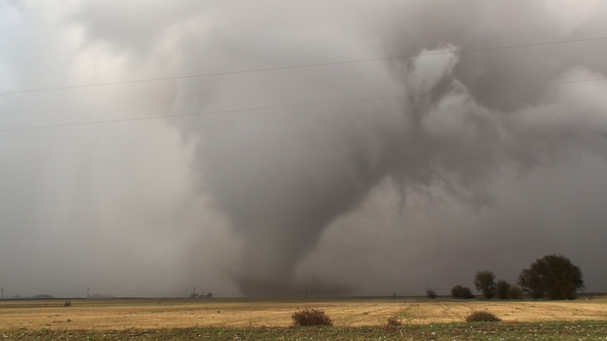
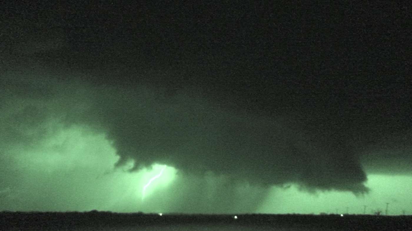
This cell got north of me also, but was able to make good time up the deserted FM1126 and cut back N on I-45.  It got a tornado warning sometime during this period.  I caught the cell again right as it entered Ennis. Turned NE on 34 and almost immediately observed a tornado at around 7:00 p.m. Due to trees and limited lightning, I wasn't sure initially, but video reveals it was on the ground to my NE close to the highway.


I soon got a good unobstructed view and stopped to film briefly and report the tornado.  It grew to a nice cone, although it never got very wide from my perspective.  Continued NE on 34 filming the tornado out the driver's side window until it roped out around 7:08.  Here is a series of shots as I traveled NE on Hwy 34 and filmed the tornado out the driver's side window.


Location on map below- looking N at 7:05


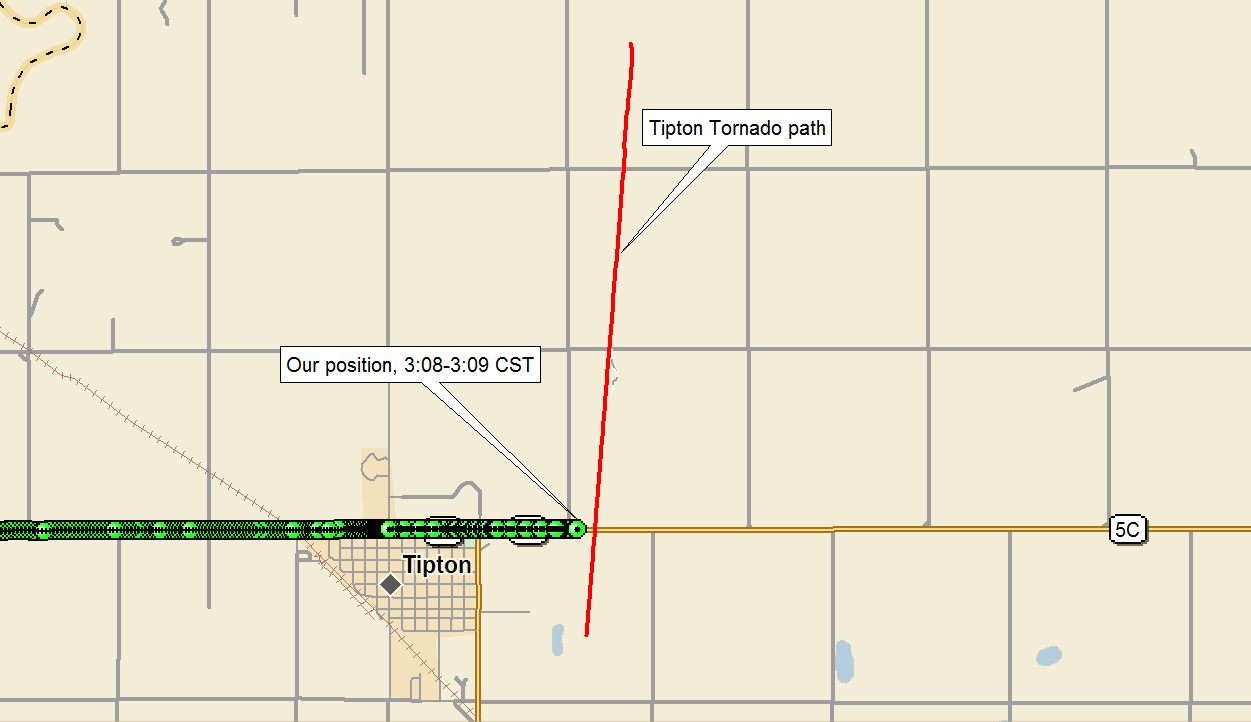
And my track and location.  Ennis is the town in the lower left: 


I followed the storm for another 90 minutes as it occasionally pulsed up and produced new wall clouds and tornado warnings. Observed no more tornadoes from it and no more have been surveyed.

Driving home on I-30, I encountered traffic completely stopped about two miles east of the bridge over Lake Ray Hubbard. Fortunately was able to exit before I got stuck. At the time I did not know about the Rowlett/Garland tornado that crossed I-30 and produced major damage and fatalities. Detoured down to US80 along with a long line of other motorists and eventually got back home just under 12 hours from when I had left.

Here is the GPS track from the active part of the storm chase, from 3:15 until ~8:20 when I gave up near Caddo Mills


This was my first December tornado and first tornado east of I-45 in Texas.  

595 miles
11 h 55 m
Solo chase

Sunday, March 1, 2015

Chase Report: 28 April, 2014 - Louisville, MS EF4


EF4 tornado, looking NNW towards Louisville, MS


After two grueling and mostly fruitless days (saw the Vilonia EF4-producing cell from 20 miles west on 4/27), I departed De Valls Bluff, AR with a general target of Clarksdale, MS.  Conditions were pegged for strong tornadoes.  SPC initially issued a moderate risk, but upgraded to Hi on the 20Z outlook, with 30% hatched tornado area.


For the remainder of the discussion, all locations are in the state of Mississippi.  Shortly after I got to Clarksdale, storms fired and were quickly tornado-warned.  I intercepted two warned cells near Grenada netween 1:25 and 2:30 CDT.  Storm motion was fast, and it was very difficult to keep up with them.  One of these went on to produce the Tupelo EF3, but not sure which.

Dropped south and caught a warned cell east of Winona shortly after 3:00.  This cell produced a confirmed tornado near Kilmichael.  I caught the wall cloud/funnel feature shortly after that, and it appeared to have a tornado on the ground the only time terrain allowed me a view:


Ground level is still blocked, and surveys either did not cover this area or did not find damage .  I followed it east to Europa.  Once it got a little further north, only the massive wall cloud was visible.  This area is extremely rural, so it is possible it did produce somewhere along that stretch, but no further damage was surveyed.

By this time, numerous tornado-warned cells, several with confirmed tornadoes, had developed to my south, so I started stair-stepping south.  Picked the first one up between Europa and Ackerman.  Although it looked nice visually, the next cell in line had a confirmed tornado. At 3:58 CDT, I left the Ackerman cell and then barreled south towards Louisville.

Now, I was in the unfortunate position of approaching a storm with a confirmed, damaging tornado from the north.   I reached the intersection of Highways 14 and 25 at 4:16 CDT just west of Louisville.  The northern flank of the cell was beginning to impact the city at that time.  The choice was to drop south to Highway 15 and hope like hell I beat the tornado, or go further east on 14 and try to find another vantage point.  I immediately decided to go east- had I gambled and went south, I would have either gotten an amazing up-close view of the tornado or been impacted by it- not a risk worth taking:


I nervously zig-zagged through the center of town, and cut SE on Highway 397.  Continued on that road until at 4:27 CDT, I found an opening in the treeline looking.  The wedge tornado was visible through the trees to my NW moving NE along the southern edge of town.


I observed for several minutes as it moved to my north.  Then headed north back towards town to try to follow it NE.  I ran into the damage path moments later.  Several trailers had been destroyed, and numerous trees were down.  I stopped and walked through the damage area with some locals calling out for victims.  We were unable to locate anyone- I do not believe any of the fatalities from the tornado were from that location, although I do not know for sure. I stopped my search when a second tornado-warned cell approached our location and begin producing lightning strikes.


Position and approximate view angle, 4:27 - 4:34 CDT

Here is the initial NWS assessment of the Louisville tornado, which claimed 10 lives:

PUBLIC INFORMATION STATEMENT
NATIONAL WEATHER SERVICE JACKSON MS
936 PM CDT TUE APR 29 2014

...NWS DAMAGE SURVEY FOR 04/28/14 TORNADO EVENT...

.LOUISVILLE TORNADO...

RATING:                 EF-4
ESTIMATED PEAK WIND:    185 MPH
PATH LENGTH /STATUTE/:  35.5 MILES
PATH WIDTH /MAXIMUM/:   3/4 MILE
FATALITIES:             9
INJURIES:               UNKNOWN

START DATE:             APR 28 2014
START TIME:             351 PM CDT
START LOCATION:         2 NNE RENFROE
START LAT/LON:          32.888/-89.443

END DATE:               APR 28 2014
END TIME:               447 PM CDT
END LOCATION:           5 NNE LOUISVILLE
END LAT/LONG            33.194/-89.001

SURVEY_SUMMARY: THIS TORNADO PRODUCED A LARGE
AREA OF EF2 TO EF4 DAMAGE ALONG ITS PATH.
HUNDREDS OF STRUCTURES WERE HEAVILY DAMAGED
AND THOUSANDS OF TREES WERE SNAPPED AND
UPROOTED. THE EF4 DAMAGE CONSISTED OF SEVERAL
HOMES AND APARTMENTS THAT WERE REDUCED TO
SLABS...INDUSTRIAL BUILDINGS THAT WERE
COLLAPSED...CHICKEN HOUSES THAT WERE
COMPLETELY DESTROYED WITH LITTLE TRACE
LEFT OF THEM...DEBARKED AND DENUDED TREES
AND A COLLAPSED CELL TOWER.

And here is their excellent write-up of the event:

http://www.srh.noaa.gov/jan/?n=2014_04_27_28_29_winston_tor


Departed Louisville and drove south with no radar for another hour or so.  I would catch another cell north of Edinburg, and another southwest of Carthage, both with reported tornadoes.  In both cases, I was too late to witness any tornadoes with these cells.

Continued south where I caught another tornado-warned cell near Morton.  Was approaching from the north again, though, and could not get into favorable position.  With roads flooding, fading daylight, and extremely poor terrain...


...I decided to call it quits, and headed west on I-20 towards home.

4 day solo chase total: 2,120 miles


Chase Report: 13 April, 2014 - Dublin, TX wall cloud

Wall cloud near Dublin, TX, 6:15 CDT, looking ~West from SR6


First chase day of 2014.  Not much to tell.  I screwed up and went straight up 35 to Fort Worth. Ended up 130 miles east of initiation.  Moving west and then south, intercepted one cell that fizzled, then dropped south to Dublin, where I caught the wall cloud shown above.


Looked like it meant business when I first got to it...


But it became disorganized quickly after that.  Ran into fellow Austin chaser Bill Tabor somewhere around this time.  Then dropped south trying to get in front of a townado-warned cell near Lampassas,  Got some nice shots looking east of one of the towers with pileus with the setting sun providing some nice colors.  


505 miles total

Sunday, May 11, 2014

2013: The year in review


East of Lawton, OK, driving north towards wall cloud.  A sign of how my season would go...


In 2013 I either chased the wrong storm, the wrong day, had vehicle issues, or made tactical errors. The end result, despite seeing a few good storms, was a complete tornado shutout.  The highlights and lowlights:
  • 8 chase days
  • Best chase: April 17th, Monster supercell over Lawton, OK.  This did produce at least one confirmed tornado, but we were not in the right place to see it
  • Worst chase: May 19th.  Missed brief rope tornado new Viola, KS, and I still don't know how we didn't see it.  We were watching the wall cloud/funnel and it was very briefly obscured by a rain curtain, during which time it did this:
  • Image courtesy of Randy Denzer/David Douglas


  • Worst chase, part 2:  After missing the above tornado, we couldn't keep up with the cell, which produced an EF2 on the southwest side of Wichita.  We dallied way too long in southern KS then, while a long-track EF4 struck the town of Shawnee, OK to our south.
  • Worst No-Chase.  After missing the tornadoes on May 19th, we drove through Norman and all the way back to Austin, as we could not stay for the May 20th setup.  
  • Worst Chase, runner up: May 29th.  Made it to Abilene in the Subaru, but the tires were apparently screwed up, and I could go no faster than about 55.  I decided to rent a car at the Abilene airport, and continued north.  This 1075 mile chase netted me two tickets (one speeding in the rental, one registration expired while in the Subaru).  Chased early crapvection, then one decent cell into southwest OK.  I gave up on that cell and headed back to Abilene as I had to get the rental back to the airport before they closed for the day.  Of course, shortly after I turned, it produced a brief, weak tornado near Vinson, OK.  Limped back home in the right lane of the interstate in the wounded Subaru.
  • Worst No-Chase, runner up: May 31.  

Two monster wall clouds for comparison, one over open country and the other over a medium-sized city:

Pearsall, TX: March 31, 2013


Lawton, OK: April 17, 2013


Shot of the year:

Pearsall, TX: March 31, 2013

Actually had some better shots of an incredible, stacked-plat LP near Evant TX from May 15th, but apparently I deleted that video by accident.  Yep, it was that kind of year...

Saturday, May 3, 2014

2012: The Year in Review


Weak Tornado near Kingfisher, OK
5/29/2012

Yes, it's been a while since I have updated the site.  Haven't had a lot to report.  To catch up quickly, I am going to briefly summarize 2012 and 2013- two years of my chasing career that I'd rather forget.  First, 2012...
  • 9 chase days
  • 1 cracked windshield - 5/29/2012 Just NW of Oklahoma City
  • 1 tornado - 5/29/2012 near Kingfisher, OK.  EF0 crop-swirler which persisted for ~ 3 minutes.  It later produced a well-defined white cone tornado near OKC about the time I was getting pummeled with baseball to softball-sized hail
  • Ran out of gas in Nowhere, New Mexico on the evening of 10/12/2012. 
  • Chased LA gulf coast Christmas day
  • A lot of good storms, but not a lot to show for it
  • I thought 2012 was a bad year... until 2013 

Shot of the year:

Massive Wall Cloud near Guthrie, TX
5/30/12

Wednesday, November 9, 2011

Chase Report: 7 Nov, 2011 - SW Oklahoma Cyclic Tornadic supercell


Tornado intercept near Tipton,OK - 3:01-3:15CST


Tornado SSW of Snyder, OK, ~3:23 CS
T


The Details
Departed Austin with chase partner John S at about 7:30 a.m. Slight risk for southern plains, with hatched 10% tornado in SW OK:


Forecast parameters looked good for NW TX/SW OK, including 1000-1500 CAPE and nicely veered profiles. There was some concern that overly moist atmosphere and lack of Convective Inhibition would create conveyer-belt showers and hurt the prospects for discrete cells. Still, with a healthy November jet moving in, and such impressive forecast profiles, felt like it was worth a shot.

Initial target was Childress, TX. By the time we got to Anson, elongated cells were already forming in the east TX panhandle- several hours ahead of forecast initiation from the NAM or HRRR models. Decided to go NE to Vernon to try and stay in front of the activity. Caught initial cell near Quanah, TX and followed it across the Red River on 6. It produced several strongly-rotating lowerings, and one RFD that blew a huge red dust cloud over the vehicle. We did not witness a confirmed tornado from this cell. Images below from 2 p.m. CST, just south of the Red River.


Meanwhile a cell to our SE had quickly become supercellular as it crossed the River. We went South and East out of Olustee, and got our first glimpse of what would shortly become the Tipton tornado. Hail shaft, rain free base, and lowering already apparent, roughly 15 miles away. Time is 2:49, view is SE:

By the time we turned east on 5 and began to approach the town of Tipton, we had a great view of the back side of the cell, with a beautiful hail shaft obscuring a violent tornado in progress. Time is 3:01, view is east:


Shortly after driving through Tipton, we observed the big, dusty tornado as it crossed hwy 5C just to our east at 3:08 CST. Link to youtube video and stills below:

Here is our position for the picture above:

We move slightly east and stopped again, observing the Tipton Tornado move north. Time is 3:10-3:12 CST, view is N:


Over the next couple of minutes, the tornado ropes out. Time is 3:15, View NW:


Here is the NWS PNS regarding this tornado:
PUBLIC INFORMATION STATEMENT
NATIONAL WEATHER SERVICE NORMAN OK
400 PM CST THU NOV 10 2011

...TIPTON TORNADO RATING UPGRADED TO EF4...

BASED ON ANALYSIS OF DATA COLLECTED DURING A GROUND DAMAGE SURVEY...
THE RATING FOR THE NOVEMBER 7TH TIPTON TORNADO HAS BEEN UPGRADED TO
EF4 ON THE ENHANCED FUJITA SCALE. THE RATING IS BASED PRIMARILY ON
DAMAGE OBSERVED AT THE OSU AGRONOMY RESEARCH STATION ON HIGHWAY 5.

THIS IS THE FIRST NOVEMBER EF4 TORNADO IN OKLAHOMA SINCE RECORDS
BEGAN IN 1950.

ESTIMATED WIND SPEEDS IN AN EF4 TORNADO RANGE FROM 166 TO 200 MPH.
As the initial tornado was dissipating, a large low wall cloud formed and begin to produce brief vortices to our NE. Seconds later, the tornado consolidated. Time is still 3:15CST, view is ENE:


We drove east to Manitou, then north up 183, observing the tornado strengthen into a stout stovepipe. View approximately NE, time is 3:20 - 3:24.


The tornado began to weaken as it appraoched 183. It produced this needle funnel in the center of the broad circulation, and seemed to rapidly dissipate shortly thereafter. View is North, time 3:25 CST:


Here is out track and the approximate tornado track during this intercept:


We went east on 62 east of Snyder, where we observed this brief tornado just north of the highway. Time is 3:38, view N.


I believe this tornado briefly had a satellite tornado, but was unable to video this feature. During this same time frame, observed a white funnel under a separate circulation which produced a couple brief surface spinups. Time is 3:40, View N:


Turned north on 54, and then east on mud road E1590. John kept us between the ditches on the treacherous mud roads for the next few minutes, and we witnessed the initial stages of the Wichita Mountain tornado. Time is 3:51, view is E:

We took “Scenic Highway” east, hoping we could catch the cell once we got to the other side. This strategy failed miserably, but we were able to witness the large tornado from time to time when terrain was favorable. Time is after 4:07, view is NNWish:

Here is our position for this leg of the chase, up until the GPS software failed.


Slow traffic and wandering Buffalo killed any hope of catching the cell again.

We dropped south to Wichita Falls, and then to Electra where we intercepted another supercell shortly after sunset. By the time we got to it, the storm had weakened below severe limits, and we ended the chase.

NWS Norman page on Nov 7 tornadoes

Depart: Austin, TX 7:30 a.m.
Arrive: Austin, TX 12:30 a.m.
980 miles, 17 hours