Chase Report: 7 Nov, 2011 - SW Oklahoma Cyclic Tornadic supercell

Tornado SSW of Snyder, OK, ~3:23 CST

Forecast parameters looked good for NW TX/SW OK, including 1000-1500 CAPE and nicely veered profiles. There was some concern that overly moist atmosphere and lack of Convective Inhibition would create conveyer-belt showers and hurt the prospects for discrete cells. Still, with a healthy November jet moving in, and such impressive forecast profiles, felt like it was worth a shot.
Initial target was Childress, TX. By the time we got to Anson, elongated cells were already forming in the east TX panhandle- several hours ahead of forecast initiation from the NAM or HRRR models. Decided to go NE to Vernon to try and stay in front of the activity. Caught initial cell near Quanah, TX and followed it across the Red River on 6. It produced several strongly-rotating lowerings, and one RFD that blew a huge red dust cloud over the vehicle. We did not witness a confirmed tornado from this cell. Images below from 2 p.m. CST, just south of the Red River.


Meanwhile a cell to our SE had quickly become supercellular as it crossed the River. We went South and East out of Olustee, and got our first glimpse of what would shortly become the Tipton tornado. Hail shaft, rain free base, and lowering already apparent, roughly 15 miles away. Time is 2:49, view is SE:

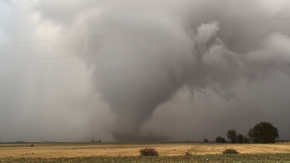
By the time we turned east on 5 and began to approach the town of Tipton, we had a great view of the back side of the cell, with a beautiful hail shaft obscuring a violent tornado in progress. Time is 3:01, view is east:

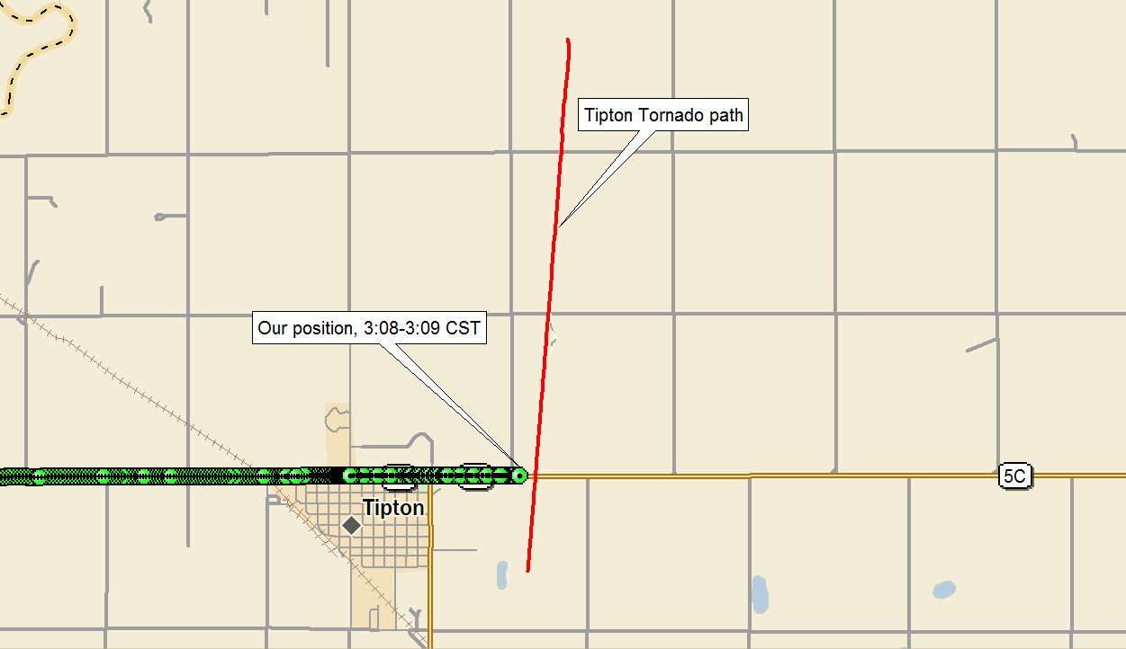
Shortly after driving through Tipton, we observed the big, dusty tornado as it crossed hwy 5C just to our east at 3:08 CST. Link to youtube video and stills below:

Here is our position for the picture above:
We move slightly east and stopped again, observing the Tipton Tornado move north. Time is 3:10-3:12 CST, view is N:


Here is the NWS PNS regarding this tornado:
PUBLIC INFORMATION STATEMENT
NATIONAL WEATHER SERVICE NORMAN OK
400 PM CST THU NOV 10 2011

...TIPTON TORNADO RATING UPGRADED TO EF4...

BASED ON ANALYSIS OF DATA COLLECTED DURING A GROUND DAMAGE SURVEY...
THE RATING FOR THE NOVEMBER 7TH TIPTON TORNADO HAS BEEN UPGRADED TO
EF4 ON THE ENHANCED FUJITA SCALE. THE RATING IS BASED PRIMARILY ON
DAMAGE OBSERVED AT THE OSU AGRONOMY RESEARCH STATION ON HIGHWAY 5.

THIS IS THE FIRST NOVEMBER EF4 TORNADO IN OKLAHOMA SINCE RECORDS
BEGAN IN 1950.

ESTIMATED WIND SPEEDS IN AN EF4 TORNADO RANGE FROM 166 TO 200 MPH.

We drove east to Manitou, then north up 183, observing the tornado strengthen into a stout stovepipe. View approximately NE, time is 3:20 - 3:24.


The tornado began to weaken as it appraoched 183. It produced this needle funnel in the center of the broad circulation, and seemed to rapidly dissipate shortly thereafter. View is North, time 3:25 CST:

Here is out track and the approximate tornado track during this intercept:

We went east on 62 east of Snyder, where we observed this brief tornado just north of the highway. Time is 3:38, view N.

I believe this tornado briefly had a satellite tornado, but was unable to video this feature. During this same time frame, observed a white funnel under a separate circulation which produced a couple brief surface spinups. Time is 3:40, View N:

Turned north on 54, and then east on mud road E1590. John kept us between the ditches on the treacherous mud roads for the next few minutes, and we witnessed the initial stages of the Wichita Mountain tornado. Time is 3:51, view is E:

We took “Scenic Highway” east, hoping we could catch the cell once we got to the other side. This strategy failed miserably, but we were able to witness the large tornado from time to time when terrain was favorable. Time is after 4:07, view is NNWish:

Here is our position for this leg of the chase, up until the GPS software failed.

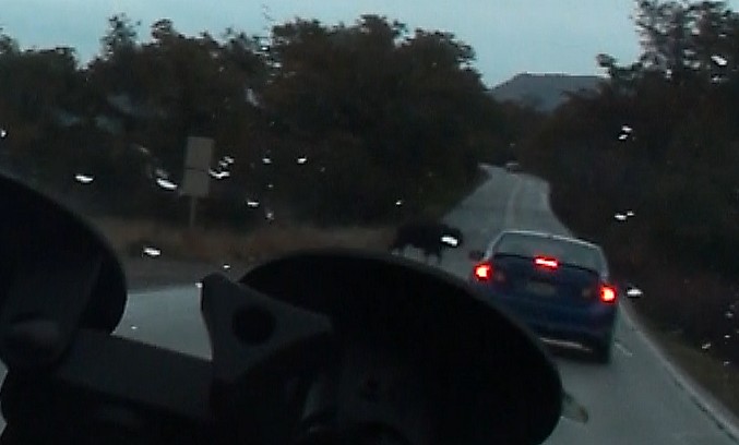
Slow traffic and wandering Buffalo killed any hope of catching the cell again.

We dropped south to Wichita Falls, and then to Electra where we intercepted another supercell shortly after sunset. By the time we got to it, the storm had weakened below severe limits, and we ended the chase.
NWS Norman page on Nov 7 tornadoes
Depart: Austin, TX 7:30 a.m.
Arrive: Austin, TX 12:30 a.m.
980 miles, 17 hours
posted by Tony C at
1:42 PM
![]()

0 Comments:
Post a Comment
Subscribe to Post Comments [Atom]
<< Home