Chase Report: 10 May, 2010, Part 2 - Pharoah/Henryetta, OK tornadoes

Part 2:
Storms had fired SW of OK City and quickly gone severe. As I quickly made my way South down 81 and then SE on 3 towards OKC, a problematic issue soon became apparent. These storms were tracking into a major population center right at rush hour. Rather than try to drive into the city, I decided my best bet was to go around the north side and pick cells up as they moved east out of town.
Tornado warnings began sounding fast and furious, and I intercepted my first tor-warned cell for the day at Hwy 3 and the turnpike ~ 5 N of Yukon. Thought it was going to drop a tornado right in front of me based on the amazing low level rising motion and rotation, but it was a bit disorganized. I continued on the turnpike around the N side of OKC, and then went NE on the turnpike to try to keep up with the tornado-warned cell. Caught a few glimpses of a nice funnel through the trees, but AFAIK, this cell did not produce north of the city (it did produce west of OKC near Yukon, before I got to it):

The problem with Turnpike chasing is that there are not many exits. The cell that produced the funnel cloud continued moving NE of the turnpike away from me, while the cells south of OKC went crazy, dropping damaging tornadoes, including two EF4's. I cut south on 177 and drove down to Shawnee on I-40. As I approached, an EF3 was in progress, although I did not know it at the time. I knew I did not want to core punch it, so I delayed just a bit. That storm got ahead of me, although I observed some insane motion behind the hook N of Shawnee along I-40. Time-lapse sequence appears to show a horiontal roll propagating westward on I-40, with some vertical funnels. Hopefully, I will be able to add a video clip of that soon.
I lost data at this time, so was going off warning info from the NWS and tracking the cell south of 40. Reports from Vortex2 and other chasers were of a large tornado in progress with this cell- that tornado ended up getting and EF3 rating, Talked to fellow Austin chaser David Douglas as I went east on 40, and thanks to his help, figured I had a chance to catch the cell south of 40. I thought I was going to have to get off of 40 and drop south at some point. However, from damage surveys, it appears the large EF3 dissipated, and a new tornado developed S of Okemah. I am certain that this new tornado is the one I witnessed. It was to my SW when I first saw it, and I immediately pulled over and began filming. Time is ~7:00 pm CDT. View is SW, looking out the side passenger's window of my car:


Here is the damage survey from Tulsa NWS for this tornado, which was rated EF1:
ANOTHER TORNADO DEVELOPED ABOUT 6.5 MILES SOUTH OF OKEMAH AT ABOUT 645 PM.

THE TORNADO MOVED NORTHEAST AND DISSIPATED ABOUT 2.75 MILES NORTH-NORTHWEST

OF PHAROAH AT ABOUT 710 PM. TREES WERE SNAPPED...POWER POLES WERE DOWNED...

HOMES WERE DAMAGED AND SEVERAL OUTBUILDINGS WERE DESTROYED WITHIN THE 14 MILE

LONG PATH THAT WAS A MAXIMUM OF 1000 YARDS WIDE. BASED ON THIS DAMAGE...THE

TORNADO WAS RATED EF-1 ON THE ENHANCED FUJITA SCALE WITH PEAK WINDS NEAR

105 MPH.
The wall cloud had what appeared to be a stovepipe tornado on the ground sporadically. My position relative to the storm resulted in relatively low-contrast video again, with a curtain of white precip wrapping quickly around the tornado.
After the tornado disappeared in precip, I continued east on 40, since I was not sure of its motion. It was indeed coming in my direction, and crossed the interstate about 4 W of where I had been sitting shortly after I moved. Below is my GPS location and the appx. tornado track based on Tulsa survey, located here:

http://www.srh.noaa.gov/news/display_cmsstory.php?wfo=tsa&storyid=52278&source=0
As I approached Henryetta, evidence of a new, low wall cloud appeared south of town. Reviewing the video, and combined with Tulsa NWS Survey, and pictures from other chasers who were further south, it appears this wall cloud had occasional funnels and was causing tornadic damage at the ground. This is similar to the appearance of the downtown Nashville EF3 in its formative stages.
Here is a sequence of images taken from ~7:10-7:17 CDT, initially looking SE over Henryetta, then East as the wall cloud crosses 40, then N as the wall cloud continues NE with funnels. First, my GPS track through Henryetta with the appx tornado track pre Tulsa NWS in red:

Approaching Henryetta on I-40, wall cloud on South side of city:

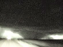
Power flash under low wall cloud over Henryetta- tornadic winds at surface with no condensation funnel:

Wall cloud over Henryetta with thin funnel right of center:

Tornadic circulation approaches I-40 just E of Henryetta:

Tornadic circulation with glow from power flash near center and thin funnel right of center approaching I-40:

Funnel cloud with thin tornado N of I-40 and E of Henryetta:

Twin funnels close to ground N of I-40 East of Henryetta:

Low funnel NE of Henryetta:

Low funnel NE of Henryetta:

Tulsa surveyed a continuous damage track from south of Henryetta over the turnpike and then I-40, crossing just east of my location. Here is the official survey, tornado rated EF2:
A STRONG TORNADO DEVELOPED AT ABOUT 704 PM ABOUT 3 MILES SOUTH- SOUTHWEST OF THE

HENRYETTA AIRPORT...MOVED NORTHEAST...AND DISSIPATED AT ABOUT 721 PM ABOUT 2 MILES

NORTHEAST OF DEWAR. THE TORNADO DESTROYED A BOAT DOCK AND A MOBILE HOME ON HENRYETTA

LAKE...DAMAGED SEVERAL OTHER HOMES AND MOBILE HOMES...PRODUCED MAJOR TREE DAMAGE...

A DESTROYED OUTBUILDINGS. THE PATH LENGTH WAS ABOUT 10 MILES AND WAS UP TO 1250 YARDS

WIDE. THE TORNADO WAS RATED EF-2 ON THE ENHANCED FUJITA SCALE WITH PEAK WINDS NEAR

115 MPH.
Continued east to Checotah, where another “large” tornado was being reported. This was from a new wall cloud which formed E of the Henryetta tornado. I had a view of the wall cloud in my video, but I had fallen slightly behind again, and could not get to the area of interest in time. Shortly after that, I had to double back about 5 miles to a gas station when the needle hit E. That was the nail in the coffin for daytime activity.
At about 9 pm CDT, I was in Warner, OK at I-40, and decided to attempt to catch one last cell. This cell was tornado-warned about 40 to my south. I went east along I-40, dropped south at Sallisaw, and caught the cell near Heavener, OK. It lost its tornado warning about the time I was getting close, but still had lots of lightning, so I was able to observe briefly. I cut east and followed the still-severe cell into Arkansas, but finally stopped in Bates, AR. The cell was not showing much rotation any more, and was getting further away.
Stayed at the “Crane” motel in Heavener- Cash only.
Depart Norman, OK: 12:30 p.m.
Arrive Heavener, AR: 12:45 a.m.
500 miles, solo chase
posted by Tony C at
12:23 PM
![]()

0 Comments:
Post a Comment
Subscribe to Post Comments [Atom]
<< Home