Chase Report: 28 April, 2014 - Louisville, MS EF4

EF4 tornado, looking NNW towards Louisville, MS
After two grueling and mostly fruitless days (saw the Vilonia EF4-producing cell from 20 miles west on 4/27), I departed De Valls Bluff, AR with a general target of Clarksdale, MS. Conditions were pegged for strong tornadoes. SPC initially issued a moderate risk, but upgraded to Hi on the 20Z outlook, with 30% hatched tornado area.


For the remainder of the discussion, all locations are in the state of Mississippi. Shortly after I got to Clarksdale, storms fired and were quickly tornado-warned. I intercepted two warned cells near Grenada netween 1:25 and 2:30 CDT. Storm motion was fast, and it was very difficult to keep up with them. One of these went on to produce the Tupelo EF3, but not sure which.
Dropped south and caught a warned cell east of Winona shortly after 3:00. This cell produced a confirmed tornado near Kilmichael. I caught the wall cloud/funnel feature shortly after that, and it appeared to have a tornado on the ground the only time terrain allowed me a view:

Ground level is still blocked, and surveys either did not cover this area or did not find damage . I followed it east to Europa. Once it got a little further north, only the massive wall cloud was visible. This area is extremely rural, so it is possible it did produce somewhere along that stretch, but no further damage was surveyed.
By this time, numerous tornado-warned cells, several with confirmed tornadoes, had developed to my south, so I started stair-stepping south. Picked the first one up between Europa and Ackerman. Although it looked nice visually, the next cell in line had a confirmed tornado. At 3:58 CDT, I left the Ackerman cell and then barreled south towards Louisville.
Now, I was in the unfortunate position of approaching a storm with a confirmed, damaging tornado from the north. I reached the intersection of Highways 14 and 25 at 4:16 CDT just west of Louisville. The northern flank of the cell was beginning to impact the city at that time. The choice was to drop south to Highway 15 and hope like hell I beat the tornado, or go further east on 14 and try to find another vantage point. I immediately decided to go east- had I gambled and went south, I would have either gotten an amazing up-close view of the tornado or been impacted by it- not a risk worth taking:

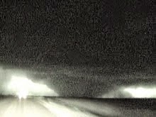
I nervously zig-zagged through the center of town, and cut SE on Highway 397. Continued on that road until at 4:27 CDT, I found an opening in the treeline looking. The wedge tornado was visible through the trees to my NW moving NE along the southern edge of town.


Position and approximate view angle, 4:27 - 4:34 CDT
Here is the initial NWS assessment of the Louisville tornado, which claimed 10 lives:
PUBLIC INFORMATION STATEMENT
NATIONAL WEATHER SERVICE JACKSON MS
936 PM CDT TUE APR 29 2014
...NWS DAMAGE SURVEY FOR 04/28/14 TORNADO EVENT...
.LOUISVILLE TORNADO...
RATING: EF-4
ESTIMATED PEAK WIND: 185 MPH
PATH LENGTH /STATUTE/: 35.5 MILES
PATH WIDTH /MAXIMUM/: 3/4 MILE
FATALITIES: 9
INJURIES: UNKNOWN
START DATE: APR 28 2014
START TIME: 351 PM CDT
START LOCATION: 2 NNE RENFROE
START LAT/LON: 32.888/-89.443
END DATE: APR 28 2014
END TIME: 447 PM CDT
END LOCATION: 5 NNE LOUISVILLE
END LAT/LONG 33.194/-89.001
SURVEY_SUMMARY: THIS TORNADO PRODUCED A LARGE
AREA OF EF2 TO EF4 DAMAGE ALONG ITS PATH.
HUNDREDS OF STRUCTURES WERE HEAVILY DAMAGED
AND THOUSANDS OF TREES WERE SNAPPED AND
UPROOTED. THE EF4 DAMAGE CONSISTED OF SEVERAL
HOMES AND APARTMENTS THAT WERE REDUCED TO
SLABS...INDUSTRIAL BUILDINGS THAT WERE
COLLAPSED...CHICKEN HOUSES THAT WERE
COMPLETELY DESTROYED WITH LITTLE TRACE
LEFT OF THEM...DEBARKED AND DENUDED TREES
AND A COLLAPSED CELL TOWER.
And here is their excellent write-up of the event:
http://www.srh.noaa.gov/jan/?n=2014_04_27_28_29_winston_tor
Departed Louisville and drove south with no radar for another hour or so. I would catch another cell north of Edinburg, and another southwest of Carthage, both with reported tornadoes. In both cases, I was too late to witness any tornadoes with these cells.
Continued south where I caught another tornado-warned cell near Morton. Was approaching from the north again, though, and could not get into favorable position. With roads flooding, fading daylight, and extremely poor terrain...

...I decided to call it quits, and headed west on I-20 towards home.
4 day solo chase total: 2,120 miles
posted by Tony C at
5:22 PM
![]()

0 Comments:
Post a Comment
Subscribe to Post Comments [Atom]
<< Home