Imminent tornado to my immediate northeast, 2 miles east of Dumas, TX

NOTE: Long report follows, but it's mostly pics.
Left Austin at sunrise with an initial target area anywhere from Lubbock, TX to Clovis, NM to SE CO/Guymon, OK. Note all times that follow are CDT, p.m.. By the time I got to Lubbock., hi-res precip models and RUC were both showing no precip south of I-40. After a quick check of SPC mesoanalysis params, decided to keep moving north. Got to Dumas, TX around 4:30 p.m. Shortly before then, a cell had fired West of Channing and was moving NE towards Hartley. By 5 p.m., I was on the cell just east of Hartley.
Drove South on FM3138. Over the next hour, the storm had ground-hugging wall clouds, and according to KAMA, produced 4 EF0 tornadoes. I was in nearly perfect position for almost all of them, but only captured two definite tornadoes on video, one of which does not correspond directly to any that KAMA logged. From KAMA surveys (italicized sections):
The first tornado touched down 4 miles south southeast of Hartley at 532 pm cdt. The tornado was on the ground for 1 mile with a maximum width of 50 yards. The tornado dissipated at 536 pm cdt. This tornado was rated an EF0. No damage or injuries were reported.
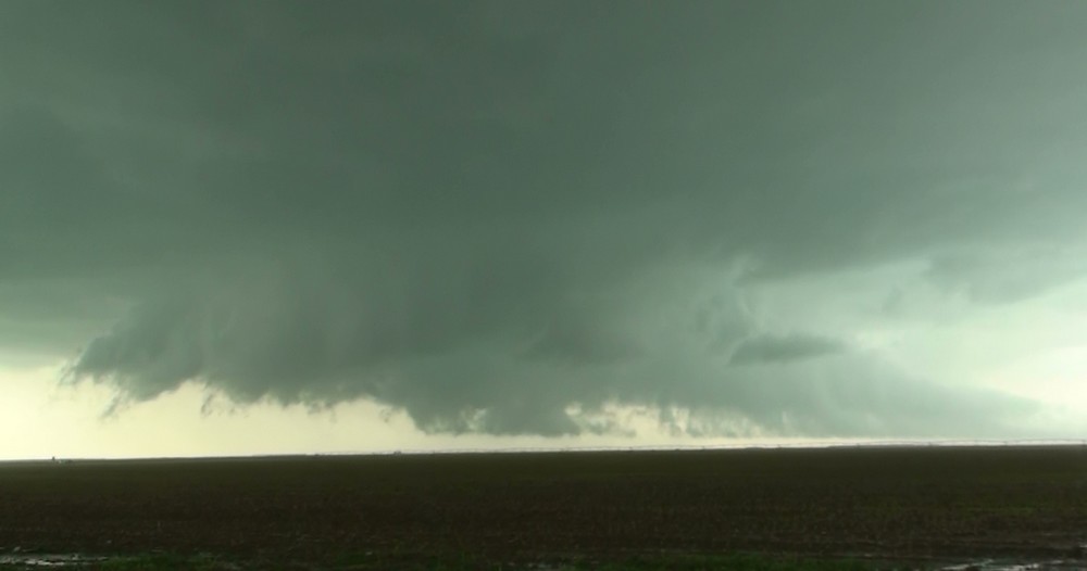
I was looking directly at this area. There was a spectacular, low wall cloud with rapid rotation, but I never saw indication that tornadic circulation was on the ground. Report is 4-5 miles to my west, so evn though I had clear view of the ground, could have missed evidence of a ground circulation. Here is the wall cloud with my position and look angle:


Continued south on FM-3138...
The second tornado touched down 8 miles southeast of Hartley at 541 pm cdt. The tornado was on the ground for 1 mile with a maximum width of 100 yards. The tornado dissipated at 544 pm cdt. This tornado was rated an EF0. No damage or injuries were reported.
Was also looking directly at this. Stopped at the intersection of FM-3138 and CR-R. One of the CSWR trucks was also scanning from this point. There was a solid wall cloud with a couple of funnels from 5:41-5:43, but no visual evidence of tornado on ground. Report is 2 miles to the west of my location (see previous map).

I turned to move east on CR-R (a dirt/mud) road to stay ahead of core, and filmed over my shoulder as I drove. There does clearly appear to be a brief tornado on the ground in that clip. Camera work is poor as I had to focus on driving and shooting over my shoulder, and could not look to see what I was filming. Tornado is slightly right of center, embedded in thin curtain of precip. Time is 5:44:

Continued east on CR-R...
The third tornado touched down 11 miles west of Dumas at 555 pm cdt. The tornado was on the ground for one half mile with a maximum width of 25 yards. The tornado dissipated at 557 pm cdt. This tornado was rated an EF0. No damage or injuries were reported.
This is where I stopped and turned briefly north on S County Line Rd. The TIV and support vehicle were also there- I think they had just driven south from under the meso (obligatory photo of TIV):

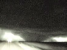
Again, strong low-level rotation is apparent, but no ground circ. Location of report is 4 miles to my North at this time, and I was moving from 5:55-5:56, but still filming in that direction. At 6:02, I did observe a brief tornado under the same circulation. This was in the wrapping rain curtain, and solidified into a darker funnel which connected to cloud base and briefly rotated beneath the wall cloud. Here is a vid cap:

At 6:12, I stopped and filmed a very low barrel lowering which appeared to possibly tornado briefly. Poor contrast and distance prevents confirmation on this one. Here's a cap and map for the time sequence from 5:55-6:12:


Continued east on CR-R, then N and NE on Ranch 722 into Dumas...
The fourth tornado touched down 2 miles south southwest of Dumas at 628 pm cdt. The tornado was on the ground for 1 mile with a maximum width of 25 yards. The tornado dissipated at 630 pm cdt two miles southeast of Dumas. This tornado was rated an EF0. No damage or injuries were reported.
I filmed the low wall cloud, which was just to me E/NE. Looks like another case where tornado was not condensed to the ground. OR I could not see it because of the rain curtains I was in, but I could see what I believe was the lowering at the center of the rotation. Cap and location:


Drove through Dumas and then east on 152...
The fifth tornado touched down 2 miles east of Dumas at 642 pm cdt. The tornado was on the ground for 1 mile with a maximum width of 200 yards. The tornado dissipated at 645 pm cdt. This tornado was rated an EF0. No damage or injuries were reported.
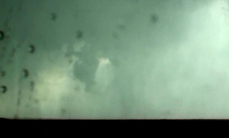
I actually observed two brief tornadoes in rapid succesion along the highway. The first was a weak multivortex with little condensation which crossed 152 less than a mile east of me. The second was a stout funnel which quickly intensified just north of the highway to my immediate NE. It wrapped up quickly and blasted me with westerly winds on the south side of the funnel. The report logs this event as one three minute tornado, but from my vantage point, I believe it was two separate touchdowns along different areas of the mesocyclone. Completely different tornadoes in appearance, location, and duration from my prespective, but it was a hectic sky, and I was having to concentrate on making sure the second tornado did not take an aberrant spin in my direction. Several other chasers got video of this and may can shed some light on the exact sequence. Hopefully, I will be able to edit video and post a clip of this tornado, because the still pic does not do it justice. Caps of the second tornado and location:


Continued east on 152.
Captured another brief tornado about 6 miles east of Dumas around 6:54. This was a solid truncated cone that seemed to occur when a rapidly rotating wall cloud suddenly split into two. I need to extract the whole video sequence- difficult to describe what I saw, and the split effect could have been an illusion. Fellow chasers Marcus Diaz and Tony Laubach also caught this same feature and identified it as a tornado. From my vantage point, it was only fully condensed for a few seconds, but was very near the ground before and after for longer. Here is a sequence of images showing the wall cloud split and tornado. Location is given in the previous map.


I continued east on 152 , and got to Stinnet ~7:50. Here is the KAMA report for the tornado that occurred north of Stinnet. :
The sixth tornado touched down 3 miles south southwest of Pringle, or 6 miles northwest of Stinnett at 744 pm cdt. The tornado was on the ground for 6 miles with a maxiumum width of 300 yards. The tornado moved to the north dissipating at 800 pm cdt 3 miles northwest of Pringle. A National Weather Service survey team found significant damage to a farm located on County Road J between County Road 8 and County Road 9. A large portion of the roof was removed from the residence with considerable damage to several small sheds in the vicinity. Numerous trees were stripped with many broken large branches. A pickup behind the residence was flipped upside down with the cab smashed. Several power poles were snapped along County Road J just to the east of the residence with additional damage sustained to a few irragation pivots. A storage bin and large fuel tank were found up to 50 yards to the east northeast of their original locations. This tornado was rated an EF2. One resident was at home at the time but no injuries were reported.
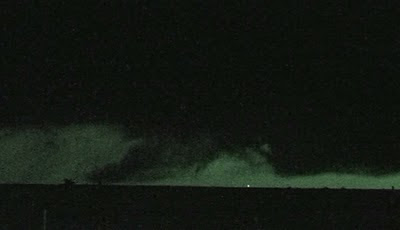
I was in West Stinnet along 152 looking North for this tornado. Could not see for most of it, as wall of precip blocked the view. Further south near my location, wall cloud with white funnels was in progress. After that feature dissipated and some of the precip cleared, the Pringle tornado becomes visible in the distance. My best estimate based on NWS survey places it ~10 miles to my N during this shot. I don't think I am seeing the actual tornado, unless it was huge, probably the parent funnel cloud, though, with low-level cloud junk and topography blocking the ground. Some other chasers were further north looking east, and their pics show a tall, thin cone funnel. Here is what I saw, contrast-enhanced to better show the funnel:


The remnant Pringle circulation crossed East of 207, after the reported dissipation time- the black wall showed a lot of weird white descending streaks on its periphery:

Not sure what phenomenon was occurring, but I suspect hail fog was interacting with the circulation. A short while later, I encountered a huge hail swath along 207, with thick hail fog. A rotating updraft came through and started lifting the fog with weak cyclonic circulation- surface temp was 51, according to Subaru thermometer. The sun is setting peacefully in the right background:

No east road out of Stinnet, and I was indecisive about what course of action to take next. Talked to David Douglas since I was not getting data, and he helped out with some much needed nowcasting. It was almost dark by then, and new cells had fired North and West of the cell I was on. Eventually, I decided to go down to Pampa and then back to North to pick my cell up again further east.
I finally managed to catch the cell again north of Miami, where it was producing a HUGE bowl wall cloud with monster lowering very close to ground. I found a good vantage point a ways away from the storm and shot vid for a while. It may have produced during this phase, but it was over unpopulated areas, and unless another chaser has pics from closer, this is yet another impossible to verify situation. Inflow to the cell was insane- I was 5-10 miles from the wall cloud, and inflow was 40+ mph sustained.

Thought I could get closer to the wall cloud by following “Quarter Horse Rd", a long and winding gravel/dirt road that eventually comes out near Canadian. This plan worked great at first, giving me several picturesque shots of the cycling wall cloud and ominous, scary hangy-down things.

The next three shots show a persistent little funnel that comes out of the lowering in the picture center. Look just to the left of the middle fencepost.

Now darker and superimposed on the left of middle fencepost:

And now right of center fencepost:

More ominous looking lowerings as cell approaches Canadian:


Qaurter Horse Rd ended up getting rough, and when I got to the part where the cell had passed over, it got muddy. With my slow progress, the rotating part of the storm began to pull away from me. Finally, I hit a point in the road that was completely washed out.

At 11:15 p.m., called the chase and backtracked to Miami, and eventually to Shamrock, TX on I-40 to setup for the next day's chase.
Here's GPS Track for the meat of the chase:

Depart Austin, TX: 7:15 a.m.
Arrive Shamrock, TX: 1:00 a.m.
840 miles , 17:45 h, solo chase